NASA
Jet Propulsion Laboratory
California Institute of Technology
Skip Navigation
menu
close modal
Stay Connected
Gallery
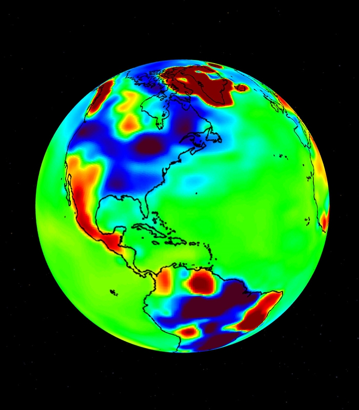
Gravity Anomaly Map Using GRACE Data
Gravity anomaly map using GRACE data.
ENLARGE
Related
The GRACE-FO satellites were assembled by Airbus Defence and Space in Germany. The photo shows one of the satellites in the testing facility of IABG, an Airbus subcontractor, in Munich (view 2).
GRACE-FO Satellites During Testing (View 2)
GRACE-Follow On (GRACE-FO) is a satellite mission that launched in May 2018. GRACE-FO will continue the work of the GRACE satellite mission tracking Earth's water movement around the globe. These d...
Tracking Water from Space
Gravity variations studied by GRACE can be used to determine ground water storage on land masses.
Global Terrestrial Water Storage Anomaly
Research based on GRACE observations indicates that between 2002 and 2016, Greenland shed approximately 280 gigatons of ice per year.
Greenland Ice Loss 2002-2016
An animation showing “sea level fingerprints,” or patterns of rising and falling sea levels across the globe in response to changes in Earth’s gravitational and rotational fields.
Cumulative Sea Level Change 2002-2015
Illustration of GRACE-FO in orbit (view 5).
GRACE-FO in Orbit (View 5)
The rainy and dry seasons in the Amazon Basin in 2004, revealed by gravity anomalies observed by GRACE. Reds and pinks show where and when mass was higher than average, a sign that more water was p...
Rainy and Dry Seasons in the Amazon (2004)
A simplified example of how the distance between the GRACE-FO satellites changes as they pass from the Caribbean Sea across Colombia and Peru.
How GRACE-FO Measures Gravity
Illustration of GRACE-FO in orbit (view 4)
Illustration of GRACE-FO (View 4)
NASAs Gravity Recovery and Climate Experiment (GRACE) has measured significant groundwater depletion around the world in recent years.
GRACE Sees Groundwater Losses Around the World
The Laser Ranging Interferometer instrument.
Laser Ranging Interferometer
GRACE Follow-On (GRACE-FO) continues the legacy of GRACE, tracking Earth’s water movement and surface mass changes across the planet. Monitoring changes in ice sheets and glaciers, near-surface and...
GRACE-FO Mission Brochure
The GRACE Intermediate Field 48 (GIF48 from UT-CSR) field model is an improved mean gravity field that combines GRACE observations and terrestrial gravity information.
Static Gravity Field Anomalies
GRACE-FO arriving at Vandenberg Air Force Base, California, from Germany.
GRACE-FO Arrives at Vandenberg
Illustration of GRACE-FO separating from Falcon 9 rocket after launch.
GRACE-FO Separating from Rocket After Launch
Changes in Australia's mass observed by GRACE in 2010 and 2011. Areas in greens and blues had the greatest increases in mass, caused by unusually high precipitation connected with a large La Niña e...
Changes in Australia's Mass Observed by GRACE in 2010 and 2011
Illustration of GRACE-FO in orbit (view 2).
GRACE-FO in Orbit (View 2)
The rocket carrying GRACE-FO lifts off into a blue sky, with the Pacific Ocean beneath it.
GRACE-FO Launch, Sky and Sea
A map of groundwater storage trends for Earth's 37 largest aquifers using GRACE data, showing depletion and replenishment in millimeters of water per year.
Map of Groundwater Storage Trends for Earth's 37 Largest Aquifers
The two GRACE-FO satellites are seen from GFZ’s Satellite Laser Ranging Station in Potsdam, Germany, on May 23, 2018 at 22:16 UTC and 22:17 UTC, respectively.
GRACE-FO Satellites From Potsdam
Flames from the SpaceX Falcon 9 rocket launching GRACE-FO into orbit.
Rocket Flames
Many of today’s most pressing climate science challenges hinge on knowing how and where water is moving on Earth. GRACE-FO will continue the successful partnership between NASA and the German Resea...
GRACE-FO Launch Press Kit
The SpaceX Falcon 9 rocket is seen with the NASA/German Research Centre for Geosciences GRACE Follow-On spacecraft onboard at Space Launch Complex 4E at Vandenberg Air Force Base in California.
GRACE-FO in Falcon 9 on Launchpad
This visualization displays monthly GRACE data in the Amazon basin, demonstrating water storage and movement.
Amazon Basin Monthly GRACE Data
Monthly changes in ocean bottom pressure data obtained by the GRACE satellites from November 2002 to January 2012.
Ocean Bottom Pressure 2002-2012
You Might Also Like
The Gravity Recovery and Climate Experiment-Continuity mission will extend a decades-long record of following shifting water masses using gravity measurements.
US, Germany Partnering on Mission to Track Earth's Water Movement
This immersive experience leverages satellite data to illustrate how climate change is impacting Earth’s water cycle.
Google's ‘A Passage of Water' Brings NASA's Water Data to Life
Early data shows the greatest net gain of water over the winter in nearly 22 years, but the state’s groundwater levels still suffer from the effects of years of drought.
US-German Satellites Show California Water Gains After Record Winter
Scientists have predicted that droughts and floods will become more frequent and severe as our planet warms and climate changes, but detecting this on regional and continental scales has proven difficult. Now a new NASA-led study confirms that major droughts and pluvials – periods of excessive precipitation and water storage on land – have indeed been occurring more often.
Warming Makes Droughts, Extreme Wet Events More Frequent, Intense
In a recent study, scientists found that a previously unmeasured source – water percolating through soil and fractured rock below California’s Sierra Nevada mountains – delivers an average of 4 million acre feet (5 cubic kilometers) of water to the state’s Central Valley each year. This underground source accounts for about 10% of all the water that enters this highly productive farmland each year from every source (including river inflows and precipitation).
NASA Measures Underground Water Flowing From Sierra to Central Valley
Researchers have untangled puzzling patterns of sinking and rising land to pin down the underground locations where water is being pumped for irrigation.
NASA Finds New Way to Monitor Underground Water Loss