News | August 20, 2019
GRACE-FO Shows the Weight of Midwestern Floods

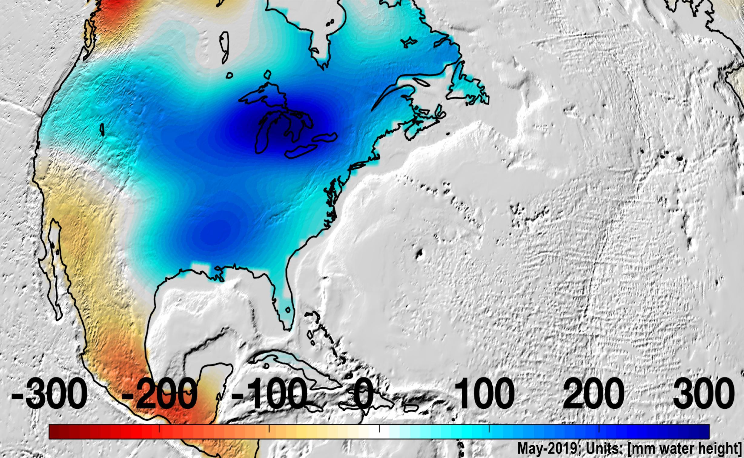
North America was almost entirely above its long-term average in mass in May 2019, due to Midwestern flooding, with the runoff raising the Great Lakes to record levels.
In May 2019, after the wettest 12 months ever recorded in the Mississippi River Basin, the region was bearing the weight of 8 to 12 inches (200 to 300 millimeters) more water than average. New data from NASA's Gravity Recovery and Climate Experiment Follow-On (GRACE-FO) mission, which launched in May 2018, showed that there was an increase in water storage in the river basin, extending east around the Great Lakes.
Data from the twin GRACE-FO spacecraft are used to measure the change in the mass of water across the planet, providing scientists, decision makers and resource managers with an accurate measure of how much water is retained - not only on Earth's surface, but also in the soil layer and below ground in aquifers. Monitoring these changes provides a unique perspective of Earth's climate and has far-reaching benefits for humankind, such as understanding both the possibility and the consequences of floods and droughts.
GRACE-FO data will soon be incorporated into the weekly U.S. Drought Monitor maps, an important tool for tracking drought across the United States. Agricultural drought depends not only on rainfall, but also on the quantity and extent of underground water available to plant roots and irrigation. GRACE-FO's estimates of subsurface water are critical to crop and water management.
The GRACE-FO science team is now looking at June 2019 data to assess how the unusually warm weather and rapid ice loss this summer will affect that trend. Greenland's significant ice melt in June and July this year was similar to the strong melting that occurred in the summer of 2012 and led to significant ice loss.
GRACE-FO is a partnership between NASA and the German Research Centre for Geosciences (GFZ). The twin GRACE-FO spacecraft are operated from the German Space Operations Center in Oberpfaffenhofen, Germany, under a GFZ contract with the German Aerospace Center (DLR). JPL manages the mission for NASA's Earth Science Division in the Science Mission Directorate at NASA Headquarters in Washington. Caltech in Pasadena, California, manages JPL for NASA.
News Media Contact
Written by Carol Rasmussen
Esprit Smith
Jet Propulsion Laboratory, Pasadena, California
818-354-4269
Esprit.Smith@jpl.nasa.gov
NASA's Earth Science News Team
2019-168


