News | August 13, 2024
Data in Action: GRACE and GRACE-FO are used by California's Department of Water Resources for Groundwater Management Information

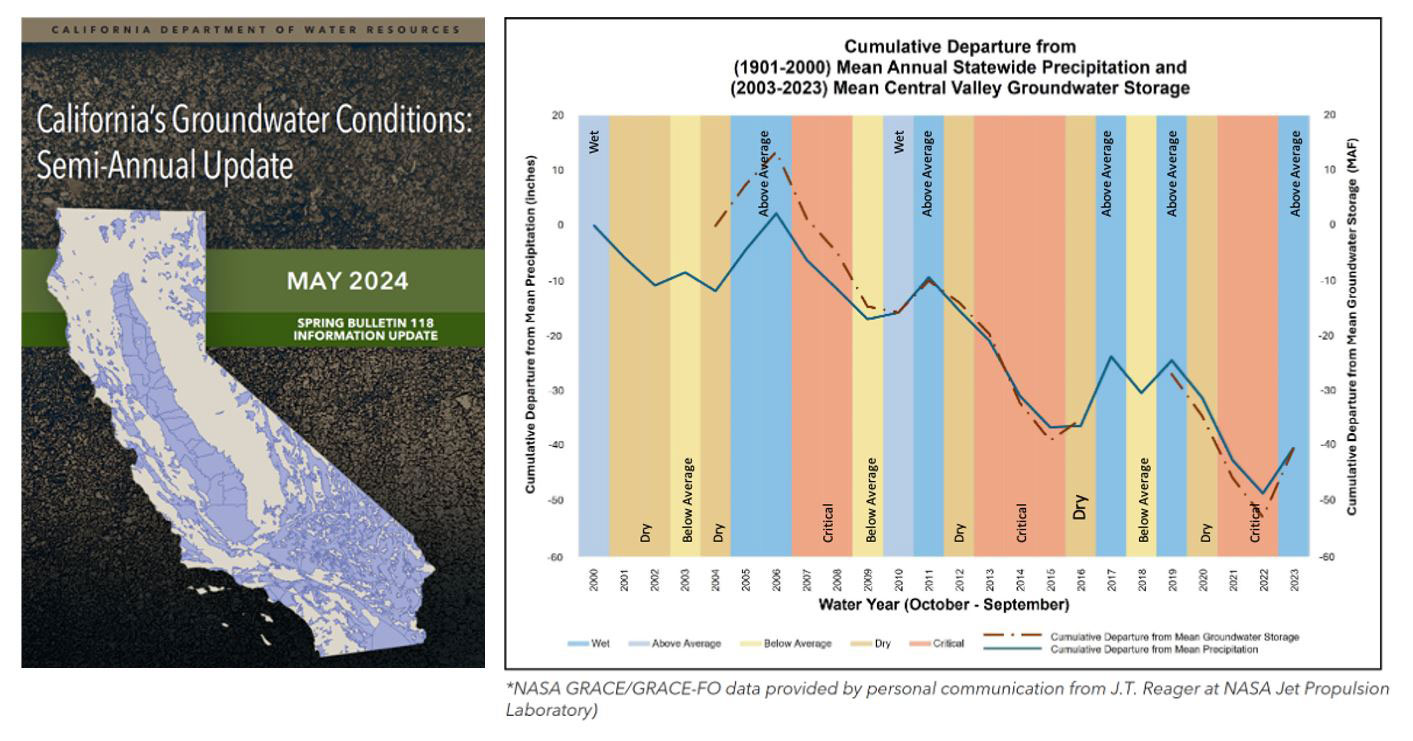
From California’s Groundwater Semi-Annual Report (CA DWR) (cover, left): cumulative departure from long term (1901-2000) mean annual statewide precipitation from NOAA National Centers for Environmental Information (solid blue) and Central Valley groundwater storage GRACE and GRACE-FO (dashed red) (plot, right).
Groundwater is the water stored beneath Earth's surface in the cracks and spaces in soil, sand and rock, and is recharged by precipitation from rain and snow. It is the largest source of usable freshwater on Earth, used mostly to irrigate crops and as drinking water. Using groundwater at a higher rate than its recharge rate is more and more common as demand increases under climate change conditions and can cause problems over the long-term such as (1) reduced ground and surface water supplies, (2) land subsidence due to a loss of support below the ground, which can damage infrastructures, (3) water quality degradation, and (4) lowering of the water table causing wells to run dry and increasing the cost of water pumping1. Water resources have been under considerable stress around the world2,3, however it is very challenging to monitor groundwater storage around the globe effectively.
To fill this observational gap, the Gravity Recovery And Climate Experiment (GRACE) satellite mission, a collaboration of the US National Aeronautics and Space Administration and German Aerospace Center space agencies (NASA and DLR, respectively), was launched in 2002, followed by the GRACE-FO (GRACE Follow-On) mission, a collaboration between NASA and Germany’s German Research Centre for Geosciences (GFZ), launched in 2018. By accurately measuring month-to-month mass changes across the Earth, GRACE and GRACE-FO help scientists estimate changes in the amount of water stored beneath the surface, which cause changes in gravity.
In the south-western United States, dry conditions have prevailed for thousands of years, and the last several decades have seen population and agricultural expansion leading to consistent groundwater overuse during drought periods. The California Department of Water Resources (CA’s DWR) mission is to sustainably manage the water resources of California, in cooperation with other agencies, to benefit the state’s people and protect, restore, and enhance the natural and human environments4. One of their key strategies is to manage CA’s essential water resources by diverting surface water surplus in wet years (e.g., 2023) towards groundwater recharge. However, their semi-annual report mentions that systematic and regular statewide recharge reporting is not established, resulting in numerous data gaps, making it challenging to capture the complete picture of recharge and implement effective management strategies5.
As of May 2024, the CA’s DWR includes GRACE and GRACE-FO data on a semi-annual basis for ‘insight for the regional changes in groundwater’, and ‘to help inform science-backed management decisions’5. The time series above, taken from the CA DWR May 2024 semi-annual update of California’s groundwater conditions, shows the groundwater storage departure from the long time mean (2003-2023) in the Central Valley based on GRACE and GRACE-FO observations. A decreasing trend in groundwater storage has been observed since 2003. Groundwater replenishment in 2005, 2010/11, 2017, and 2019 are observed, followed by critical and longer groundwater depletion periods. GRACE and GRACE-FO observations are now addressing the crucial need for sustainable groundwater management practices to ensure water resiliency amidst ongoing climate challenges in California.
| Dataset Name | Procesing Level | Start/Stop | Format | Spatial Resolution | Temporal Resolution |
|---|---|---|---|---|---|
| JPL GRACE and GRACE-FO Mascon Ocean, Ice, and Hydrology Equivalent Water Height Coastal Resolution Improvement (CRI) Filtered Release 06.1 Version 03 | 3 | to present | NETCDF-4 | 0.5 Decimal Degrees x 0.5 Decimal Degrees | Monthly - < Annual |
- 1Groundwater Foundation
- 2 Famiglietti, J. The global groundwater crisis. Nature Clim Change 4, 945–948 (2014). https://doi.org/10.1038/nclimate2425
- 3Medellín-Azuara, J., Escriva-Bou, A., Rodríguez-Flores, J.M., Cole, S.A., Abatzoglou, J.T., Viers, J.H., Santos, N., Summer, D.A., Medina, C., Arévalo, R. and Naumes, S., 2022. Economic Impacts of the 2020–22 Drought on California Agriculture. UC Merced.
- 4California Department of Water Resources
- 5CA DWR’s May 2024 report
- Figure: CA DWR’s May 2024 report
- Story writing: Severine Fournier, John T. Reager, and Felix Landerer


